GRAPHIC SUMMARY
 Authors
1. INTRODUCTION
A complex relationship between vegetation cover and soil water infiltration capacity has emerged as a key element in the search for effective solutions for sustainable water resource management (Shaikh et al., 2023). This relationship is particularly critical in urban areas, where rapid population growth increases water demand and directly affects surface runoff regulation, erosion processes, and sediment transport in watercourses (Santana et al., 2023). These dynamics pose an increasing threat to natural ecosystems (Ciupa et al., 2021).
Soil infiltration capacity is determined by a complex interaction of surface conditions, soil moisture, physical properties, and topography (Leul et al., 2023). In addition, the characteristics of the water entering the soil, including the presence of chemicals or contaminants, can influence infiltration rates (Santana et al., 2023). Accurate methods to measure and understand these processes are essential to guide sustainable water management practices while protecting soil integrity and quality. The development of improved strategies and tools is urgently needed to conserve water resources and protect soils (Magalhães et al., 2017).
Ring infiltrometers have been widely used to determine water infiltration rates in various soil types (Gregory et al., 2005; Targa et al., 2019; Revueltas-Martínez et al., 2020). These devices consist of a metal ring, typically of known diameter, that is inserted into the soil to a certain depth. Water is then poured into the ring, and the infiltration process is monitored over time. The time required for water to infiltrate a given depth is recorded, providing a measure of the infiltration capacity of the soil. This method allows for the observation of seasonal variations and the assessment of soil response under different climatic conditions, land management practices, and changes in land use, providing detailed insights into soil heterogeneity with respect to infiltration capacity (Fatehnia et al., 2016).
However, despite the simplicity of the method, the use of manual tools such as rulers and scales carries a significant potential for error due to the subjectivity of the observer and the time required for data collection (Alves da Silva et al., 2020). These factors reduce the reliability and accuracy of the measurements, leading to potential inaccuracies in the assessment of water infiltration (Targa et al., 2019; Righes et al., 2020).
To address these challenges, automated systems based on open-source electronic prototyping platforms, such as Arduino, have emerged as a promising solution for improving the accuracy and efficiency of soil water infiltration measurements (Alves da Silva et al., 2020). Ersöz et al. (2023) note that these systems can reduce the uncertainties associated with manual methods while enabling rapid field data collection, which is essential for sustainable water resource management applications.
Studies such as the ones conducted by Masseroni et al. (2016), Karami et al. (2018), and Pereira et al. (2020) have documented specific Arduino-based circuits for agricultural applications and environmental monitoring. Nevertheless, the challenges to the adoption of these systems remain, including initial cost, operational complexity, and the need for technical training for proper use. Maintenance and calibration issues are also barriers to widespread adoption. Despite these challenges, the automation of measurement devices has great potential to improve data accuracy and enhance the application of infiltration models in different regions (Alves da Silva et al., 2020). Therefore, further investigation of the synergy between technology and soil measurements is critical to advance knowledge and promote sustainable water and soil management practices in diverse locations.
This study investigates how automated systems can improve the accuracy of soil water infiltration measurements, contributing to improved strategies for sustainable water and soil management. Specifically, it uses a ring infiltrometer connected to an Arduino microcontroller and an ultrasonic sensor, with an algorithm developed in Python. This setup enabled continuous measurements of infiltration rates across a toposequence of different soil types in the Tietê-Batalha watershed in São Paulo, Brazil. The results highlight the value of integrating technology into soil measurements to advance scientific understanding and optimize water management and resource conservation under diverse soil and climatic conditions.
2. MATERIALS AND METHODS
Experimental area
The research was conducted in a section of the Tietê-Batalha watershed (TBW), located in the municipality of Piratininga, about 32 km from the city of Bauru, SP (Figure 1). The study included four field campaigns carried out on 09/07/2022, 22/07/2022, 01/08/2022, and 04/09/2022, during the winter season, which is typically characterized by low precipitation in the region (Cruciol-Barbosa et al., 2023).
The TBW is integrated into the Integrated Water Resources Management System (SIGRH), in accordance with the principles established by the São Paulo Water Law (Law 7.663/1991). Recognizing water as a public good, this system aims to promote sustainability by maintaining adequate standards of water quantity and quality to meet societal needs. The SIGRH operates under the State Water Resources Plan (PERH), which is revised every four years and is based on the watershed management plans of the 21 watershed committees in the state. The coordination of the system is led by key entities, including the State Water Resources Council (CRH), the Watershed Committees (CBH), and the Coordinating Committee for the State Water Resources Plan (CORHI).
TBW is designated as the Water Resources Management Unit of the State of São Paulo (UGRHI 16). Key characteristics of this unit include its strategic central location within the State, abundant water resources of high quality and quantity, and infrastructure conducive to agricultural, livestock and industrial investment. It benefits from an extensive road network, an efficient railway system, the Tietê-Paraná waterway, the Brazil-Bolivia gas pipeline, and the Mário Leão hydroelectric plant with a capacity of 265 megawatts (Comitetb, 2024). According to Crespo et al. (2017), UGRHI-16 covers a drainage area of 13,149 km², with a population of 537,122 inhabitants. The main rivers in the region include the Tietê, Dourado, São Lourenço, Batalha, and Ribeirão dos Porcos. In addition, there are 893 km² of remnant vegetation, including seasonal semi-deciduous forest and Cerrado (Lemes et al., 2020).
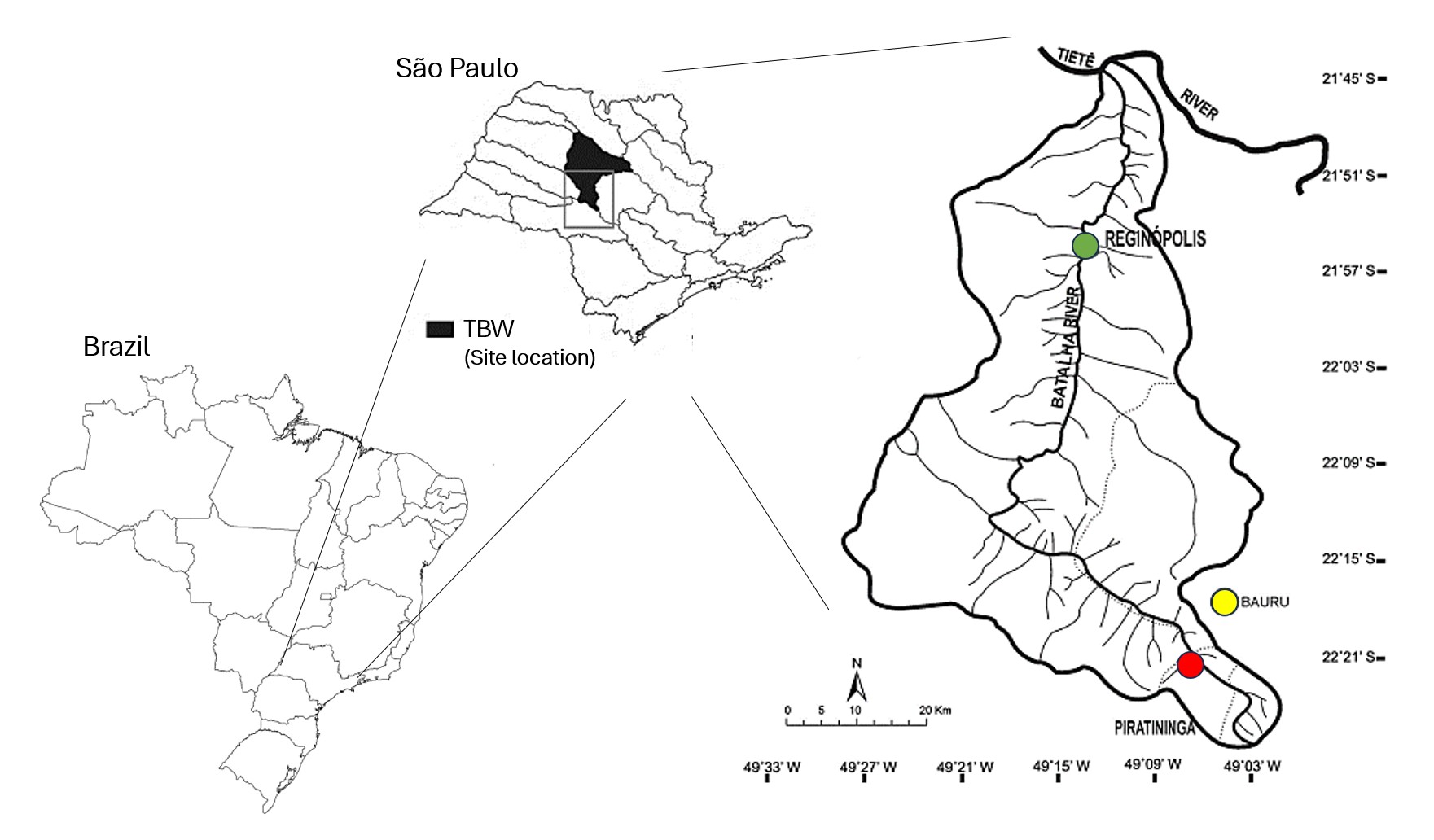 Figure 1.
The Tietê-Batalha watershed (TBW), located in the State of São Paulo (Brazil), highlighting the course of the Batalha River between the two studied stretches, Reginópolis and Piratininga. For reference, Reginópolis is shown in gray, Piratininga in red, and Bauru in yellow.
Adapted from Leite et al. (2018).
Figure 1.
The Tietê-Batalha watershed (TBW), located in the State of São Paulo (Brazil), highlighting the course of the Batalha River between the two studied stretches, Reginópolis and Piratininga. For reference, Reginópolis is shown in gray, Piratininga in red, and Bauru in yellow.
Adapted from Leite et al. (2018).
The climate of the region is tropical highland (Cwa) according to the Köppen-Geiger classification, with distinct wet and dry seasons (Cruciol-Barbosa et al., 2023). Average air temperatures range from 26°C during the hottest months to 20°C during the coldest months. Summer, from December to February, is hot and rainy, with an average monthly rainfall of 200 mm. Winter, from June to August, has cooler temperatures and less than 70 mm of rain per month. Transitional periods, from March to May and from September to November, record average monthly rainfall between 100 and 150 mm. Predominant soil types include well-developed latosolic soils with texture horizon B, and less developed hydromorphic soils in poorly drained areas and lithosols in steeper terrains (Salomão, 1994).
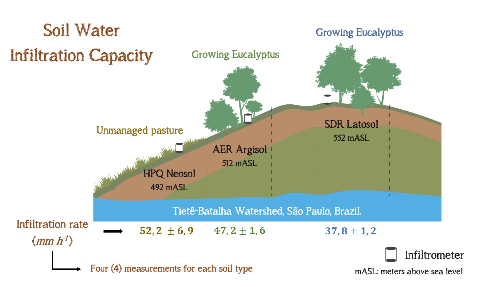
The study was conducted on a rural property of 3.4 km² (22.25 S, 49.05 W) used to grow eucalyptus for the pulp and paper industry. The experimental area followed a toposequence that included three distinct soil types: Sandy Dystrophic Red Latosol (SDR Latosol), mainly used for eucalyptus cultivation since 2019, at an average elevation of 552 m; Abrupt Eutrophic Red Argisol (AER Argisol), also used for eucalyptus cultivation, at an average elevation of 512 m; and Hydromorphic Plinthosol Quartzipsamment (HPQ Neosol), formerly used for cattle pasture and now degraded, at an average elevation of 492 m. The Batalha River, located at the bottom of this toposequence, provides a significant portion of the local public water supply. Figure 2 illustrates the three different soil types: SDR Latosol (2a), AER Argisol (2b) and HPQ Neosol (2c).
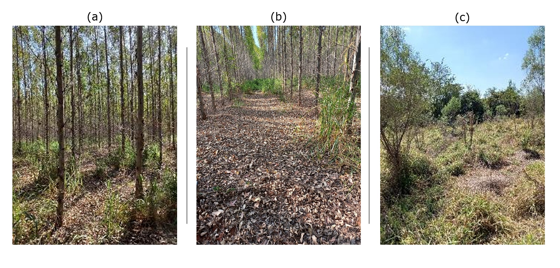 Figure 2.
Experimental areas: (a) SDR Latosol for eucalyptus planting; (b) AER Argisol, also used for eucalyptus cultivation; (c) HPQ Neosol, previously pasture, now degraded.
Authors
Figure 2.
Experimental areas: (a) SDR Latosol for eucalyptus planting; (b) AER Argisol, also used for eucalyptus cultivation; (c) HPQ Neosol, previously pasture, now degraded.
Authors
Measurement of soil water infiltration
Water infiltration into the soil was evaluated using a single-ring infiltrometer with a diameter of 0.15 m and a height of 0.30 m, following the method proposed by Bowers (1986). The device was inserted into the soil at a depth of 0.05 m. Infiltration tests were conducted after at least 10 days without rainfall, ensuring uniform soil moisture conditions. The tests were conducted between 09:00 and 11:00 on specific days, with water levels maintained between 0.02 m and 0.05 m under low hydraulic head conditions.
Infiltration velocity curves were obtained from the data collected by the automated system, which combined the single-ring infiltrometer, Arduino microcontroller, and ultrasonic sensor. Figure 3 shows the measurement system used.
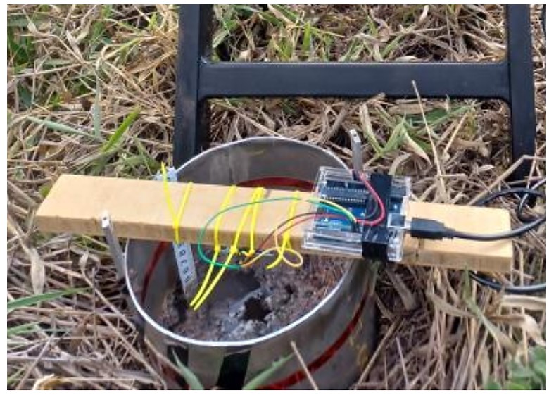 Figure 3.
Measurement of soil water infiltration using a ring equipped with automated measurement systems using an Arduino microcontroller and an ultrasonic sensor.
Authors
Figure 3.
Measurement of soil water infiltration using a ring equipped with automated measurement systems using an Arduino microcontroller and an ultrasonic sensor.
Authors
The water level inside the ring was measured using an HC-SR04 ultrasonic distance sensor connected to an Arduino Uno platform (Santos et al., 2021). The sensor emitted ultrasonic signals that reflected off the water surface, allowing for real-time data collection at predefined intervals. The Arduino was programmed to automate the sensor readings and store time and distance measurements at 15-second intervals. The data was processed using a Python algorithm that facilitated communication between the Arduino and a Python environment through the pySerial library, executed in the Google Colaboratory platform. This allowed for real-time data acquisition and processing. The full algorithm is provided in the annex (ANNEX 1).
Experimental design and statistical analysis
The experimental design was fully randomized, with four trials per soil type, spaced four meters apart. Water recharges were performed manually, and the time of each recharge was recorded by the algorithm. The difference between two consecutive readings was used to calculate the vertical infiltration rate. The automated measurements were verified against manual records for accuracy. The procedure was repeated until recharge intervals stabilized.
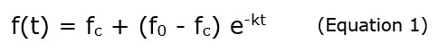
To assess the system's effectiveness in measuring soil water infiltration, the Horton equation (Thomas et al., 2020) was applied (Equation 1). In this equation, f(t) represents the infiltration rate over time; fc is the constant infiltration rate; f0 is the initial infiltration rate; and k is the decay rate. The Horton equation provides a simplified model to estimate water absorption by the soil, which is crucial for controlling surface runoff and erosion (Thomas et al., 2020). The Python algorithm used for this calculation is provided in the appendix (ANNEX 2).
A two-way analysis of variance (ANOVA) was conducted to examine the relationship between soil type and vegetation cover with respect to the fc parameter. This factorial ANOVA model assessed the main effects of soil and cover types on fc, as well as their interaction. A Tukey HSD test was conducted as a post-hoc analysis to identify differences in mean fc values among different combinations of soil and cover types. All analyses were performed at a 95% confidence level using the Python statsmodels library for statistical calculations, with additional operations conducted using the NumPy library.
To further contextualize the infiltration rates, additional data on soil texture, including proportions of sand, silt, and clay, along with density and organic matter content, were incorporated. This data was provided by the pulp and paper industry managing the site (Bracell, personal communication, 2022). Tensiometric water retention curves for soil horizons such as Ap, AB, BA, and Bw2 were also provided. These curves measure water retention at various matric potentials, offering insights into the water dynamics in each horizon (Take & Bolton, 2003). This combination of field and laboratory data provides a comprehensive understanding of the factors influencing water infiltration in the study area.
3. RESULTS AND DISCUSSION
In the toposequence (Figure 2), soil differentiation was intrinsically linked to its physical composition, specifically the proportion and distribution of soil particles. Previous studies have shown that SDR Latosol is predominantly composed of sand particles, giving it a granular texture and lower water holding capacity compared to other soil types (Pinto et al., 2019). In contrast, AER Argisol generally has a more balanced distribution of sand, silt, and clay, resulting in a well-structured profile with moderate water and nutrient holding capacity (Moreira de Oliveira et al., 2020). HPQ Neosol, likely composed primarily of sand and quartz, exhibits altered drainage conditions as evidenced by the degradation of its original structure and a corresponding reduction in nutrient and water retention capacity (Pedroni et al., 2013). These variations in physical structure—particularly the distribution of sand, silt, and clay—directly influence the characteristics and suitability of each soil type for cultivation, drainage, and water and nutrient retention.
Table 1 provides a summary of key information from each test, including soil type, collection site, average elevation, terrain slope, maximum hydraulic load applied, and the duration of each assessment. These data are essential for understanding the interactions between different soil types and the operational parameters of the tests.
Table 1.
Soil type, sampling location, average elevation, terrain slope, maximum hydraulic load during tests, and duration
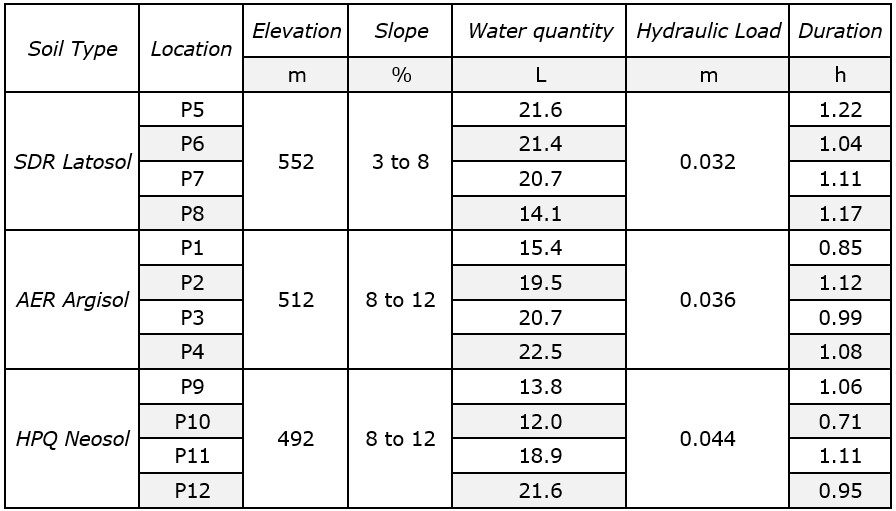 Authors Note. The data was sorted by decreasing elevation.
According to Table 1, although the differences in test durations between soil types may seem substantial, the analysis reveals no statistically significant difference in mean durations (F-statistic = 1.92, p-value = 0.20). It suggests that the observed variations may have been influenced by site-specific factors, such as local terrain characteristics or environmental conditions. In AER Argisol (P1 to P4), the test duration showed an average variation of 1.01 ± 0.12 h (11.9%), while in SDR Latosol (P5 to P8) the duration varied by an average of 1.14 ± 0.08 h (7.0%). In HPQ Neosol (P9 to P12), the tests were performed with an average duration of 0.96 ± 0.18 h (18.8%).
Similarly, no statistically significant difference was observed in the mean volumes of water used in the infiltration tests across the different soil types (F-statistic = 0.81, p-value = 0.47). On average, 19.5 ± 3.0 L (15.4%) of water was used in AER Argisol (P1 to P4) and 19.6 ± 3.6 L (18.4%) in SDR Latosol (P5 to P8). In HPQ Neosol (P9 to P12), an average of 16.6 ± 4.4 L (26.8%) was used.
Table 2 presents the textural analysis (sand, silt, and clay), density, and organic matter content for the different soil types in the toposequence, based on data provided by the pulp and paper industry responsible for the area (Bracell, 2022). Based on the physical composition of the soils in the toposequence, the comparative analysis reveals some trends, although certain results do not fully align with theoretical expectations regarding water retention and infiltration capacity for different soil types.
Table 2.
Textural analysis (sand, silt, clay), density, and organic matter across various soil types
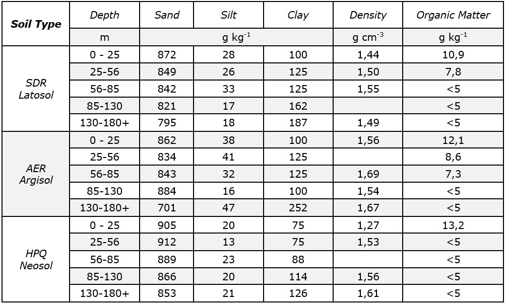 Adapted from Bracell (2022)
First, there is a correlation between the predicted physical structure and the observed results, particularly in relation to the duration of the infiltration tests. SDR Latosol, with its high sand content and lower expected retention capacity, exhibited slightly longer test durations, indicating lower water retention, consistent with the expected characteristics of this soil type. However, the volumes of water used in the infiltration tests did not quite follow theoretical expectations, as the differences between SDR Latosol, AER Argisol, and HPQ Neosol were not statistically significant at the 95% confidence level. Therefore, while some variation was observed, the data do not provide conclusive evidence of significant differences in water infiltration between soil types based solely on time and volume measurements.
In addition, SDR Latosol exhibited a density range of 1.44 to 1.55 g cm-3 at various depths, indicating a relatively consistent density throughout its profile. In contrast, AER Argisol exhibited a broader density range of 1.54 to 1.69 g cm-3, reflecting greater variability in its stratified layers. HPQ Neosol, on the other hand, generally had a lower density, ranging from 1.27 to 1.61 g cm-3, maintaining a trend toward lower density compared to the other soil types.
Figure 4 (a, b, and c) shows water retention curves for the Ap, AB, BA, and Bw2 horizons of the soils in the toposequence, using data provided by Bracell (2022). These curves illustrate volumetric moisture as a function of matric potential, covering depth ranges from 0 to 100 cm for SDR Latosol and AER Argisol, and from 0 to 140 cm for HPQ Neosol. This visual representation provides insight into the hydraulic dynamics within different soil horizons at specific depths, contributing to a deeper understanding of water behavior across the studied toposequence.
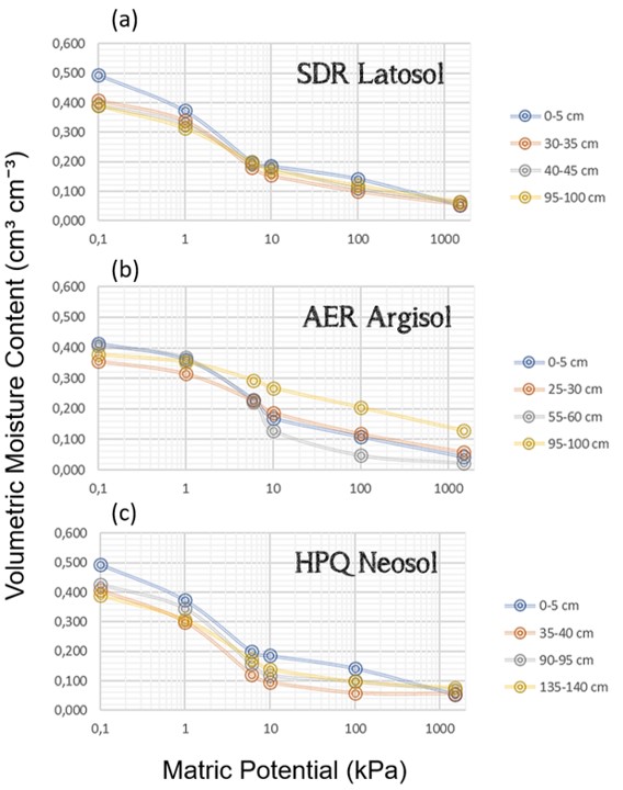 Figure 4.
Water retention curves for Ap, AB, BA, and Bw2 horizons of soils along the toposequence, based on data provided by Bracell (2022). (a) SDR Latosol, (b) AER Argisol, and (c) HPQ Neosol.
Bracell (2022).
Figure 4.
Water retention curves for Ap, AB, BA, and Bw2 horizons of soils along the toposequence, based on data provided by Bracell (2022). (a) SDR Latosol, (b) AER Argisol, and (c) HPQ Neosol.
Bracell (2022).
Based on Figure 4, the water retention curves across different soil horizons indicate significant variability in infiltration capacity, highlighting the critical role that factors such as soil texture and composition play in this process.
The predominantly sandy SDR Latosol showed high retention at low matric potentials, highlighting the significant influence of macropores. Both HPQ Neosol and AER Argisol showed favorable retention up to a certain threshold, with macropores contributing positively to water conduction. The data emphasize the heterogeneity of the toposequence and the importance of considering the unique characteristics of each soil type to effectively manage water resources tailored to the specific conditions of each area.
Measurements of soil water infiltration at TBW over time, and across different soil types, were evaluated using the Horton equation (Equation 1). Table 3 presents the fitting parameters for infiltration in the various soil types, calculated based on this model. Parameters fc and f0 are expressed in mm h−1, while k is expressed in h−1. Within the same group, letters a and b indicate statistically significant differences between the means. Soil types and vegetation covers with the same letters do not show significant differences, according to the Tukey test (p ≤ 0.05).
Table 3.
Infiltration adjustment parameters with Horton's equation across different soils and vegetation cover
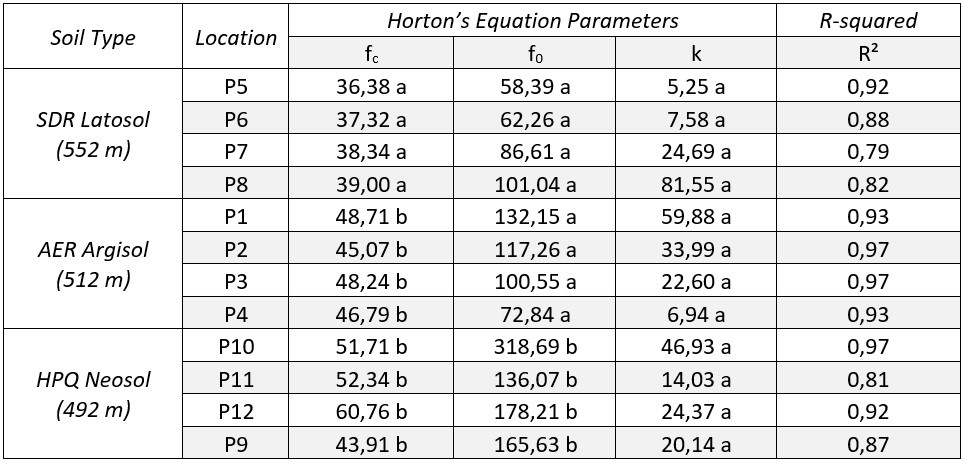 Authors Note. The same letters in the parameters indicate no significant difference (p < 0.05) between the means of each group based on Tukey's test.
According to Table 3, the coefficient of determination (R²) values ranged from 0.79 to 0.97, indicating that the Horton equation model provided a reasonably accurate representation of the infiltration rates for the different soil types. This suggests that the equation provides a satisfactory fit to the observed data, demonstrating its ability to effectively describe the infiltration processes specific to these soils.
The analysis of the fc parameter, representing the base infiltration rate, revealed variability across soil types. As shown in Figure 5 (box plot), HPQ Neosol had the highest average infiltration rate (52.18 ± 6.88 mm h⁻¹), followed by AER Argisol (47.20 ± 1.64 mm h⁻¹), and SDR Latosol (37.76 ± 1.15 mm h⁻¹). According to the Tukey test (p ≤ 0.05), means sharing the same letter are not significantly different. These results indicate that HPQ Neosol and AER Argisol presented infiltration rates approximately 38% and 25% higher, respectively, than SDR Latosol.
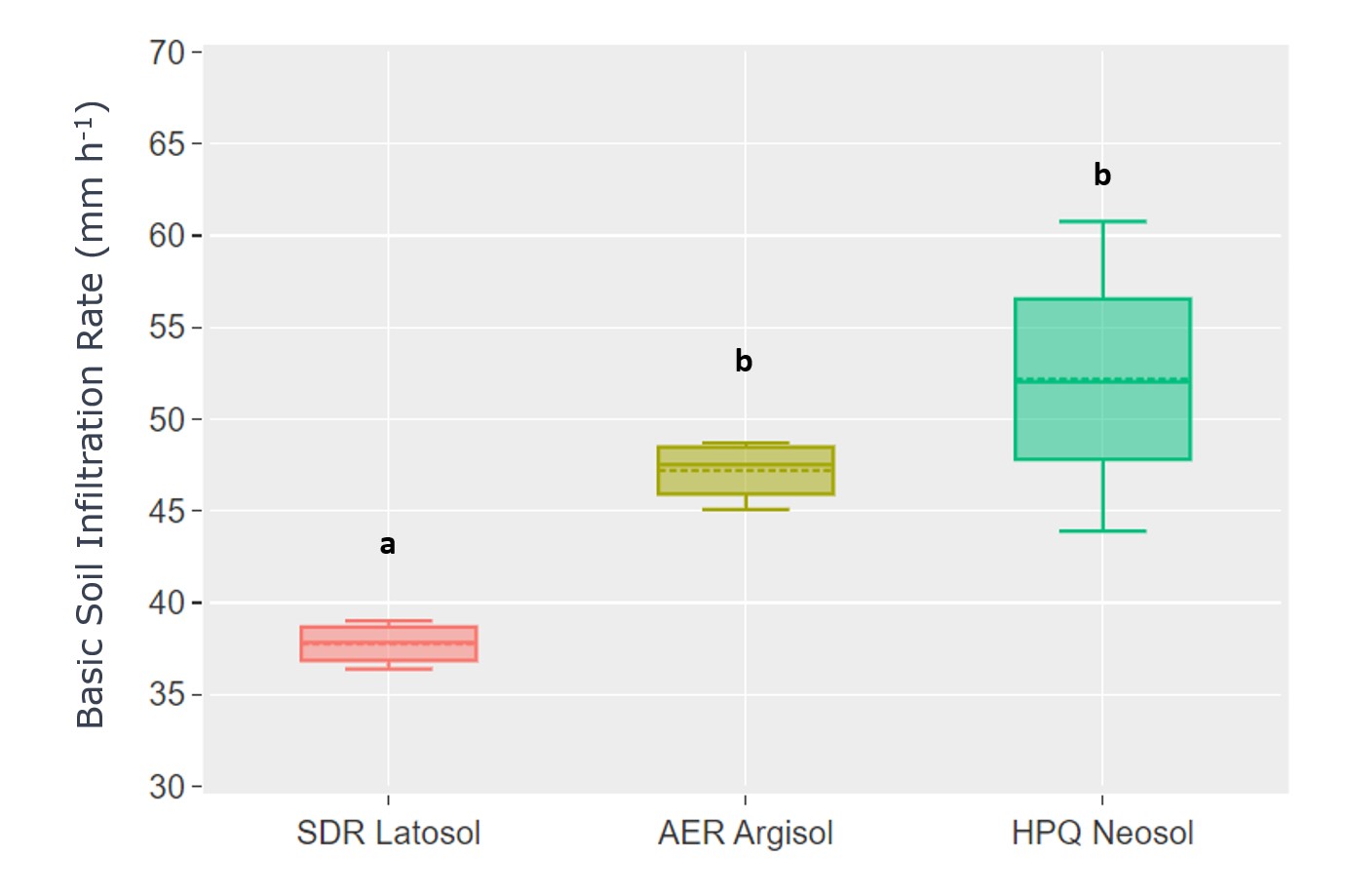 Figure 5.
Box plot of soil infiltration rates by soil type Note. Dashed lines indicate average rate. Means with the same letter (a or b) are not significantly different (Tukey test, p ≤ 0.05).
Authors
Figure 5.
Box plot of soil infiltration rates by soil type Note. Dashed lines indicate average rate. Means with the same letter (a or b) are not significantly different (Tukey test, p ≤ 0.05).
Authors
The two-way factorial ANOVA model assessed the main effects of soil type and cover type on the fc parameters, as well as their interaction. The results indicated statistically significant differences between the soil types for the evaluated parameter (p < 0.05). The Tukey HSD test, at a significance level of 0.05, revealed significant differences in mean soil infiltration rates between AER Argisol and SDR Latosol, with a mean difference of -9.44 (p = 0.0255). Additionally, a significant difference was identified between HPQ Neosol and SDR Latosol, with a mean difference of -14.42 (p = 0.0021). However, no significant differences were observed between AER Argisol and HPQ Neosol (p = 0.2574).
The results highlight a remarkable variability in infiltration capacity throughout the experimental period, reflecting the complexity of infiltration processes and the significant influence of natural soil variability on water infiltration rates. Studies such as Ma et al. (2016) and Pan et al. (2018) have similarly documented how variability in soil texture and structure affects infiltration capacity, underscoring the role of natural soil heterogeneity.
Soil texture, structure, and composition significantly influence infiltration rates, as variations in the proportions of sand, clay, and organic matter at different depths directly affect water retention and infiltration capacity. Soils with higher sand content showed increased water retention at lower matric potentials and decreased retention at higher potentials, highlighting the role of macropores in facilitating infiltration. These results are consistent with Jarvis (2020) who highlighted the importance of macropores in regulating water flow in sandy soils. Although macropores improved water movement in the surface layers, reduced retention rates could limit water availability to plants during dry periods.
The variability of data across soil types, beyond simple infiltration averages, underscores the intrinsic heterogeneity of soils that is critical to understanding hydraulic infiltration capacity. Detailed analysis of individual soil characteristics, as demonstrated by retention curves, becomes essential to accurately predict and contextualize hydraulic behavior. This level of understanding is critical for more efficient water management in agricultural and environmental settings, contributing to sustainability and optimization of water use tailored to the specific characteristics of each soil type. Similar conclusions were drawn by Korres et al. (2015), who highlighted the importance of soil-specific management practices in heterogeneous landscapes.
Although the two-way factorial ANOVA and post-hoc tests indicated statistically significant differences between some soil pairs, the lack of differences in others may reflect subtle nuances in infiltration responses that are not fully captured by the parameters considered. Soils with relatively similar physical properties may yield comparable infiltration values, making it difficult to detect significant differences. This highlights the need for further detailed investigation and refinement of measurement tools to fully understand infiltration processes in different soil contexts. In line with this, Santos et al. (2021) emphasize the importance of high-resolution temporal data to capture short-term variations in infiltration processes.
In this context, test duration plays a critical role in detecting true differences between soil groups. Short duration tests that do not allow for water level stability in the infiltrometer can limit the ability to detect significant differences, requiring a greater number of samples to reveal subtleties that might otherwise go unnoticed. This is consistent with the work of Alves da Silva et al. (2020), who found that short-term tests often fail to capture the complete infiltration dynamics, particularly in soils with variable structure.
While the automated system performed adequately in determining steady-state infiltration rates, it is important to consider the effects of manually adding water to the infiltrometer during testing. The reliability of this method depends on maintaining stable water levels over time, and manual replenishment can introduce variability into the results. The inconsistent amount of water added manually can affect the stability and accuracy of measurements, resulting in discrepancies between tests. Short-term tests may not capture the stability needed to detect significant differences between soil groups, especially if manual recharges are not standardized. This limitation underscores the need for more automation or additional controls to ensure consistency in water recharges. In addition, potential inaccuracies associated with the ultrasonic sensor, as well as interference from external factors such as environmental conditions, must be considered as they may affect the reliability of the measurement. Previous work by Masseroni et al. (2016) highlights the role of automation in minimizing such variability in field experiments.
The results of the infiltration tests provide detailed insights into the intrinsic properties of the soils being studied, with the automated infiltration system providing continuous and accurate data collection that reduces the variability typically introduced by manual methods. Understanding these processes is critical for guiding sustainable management strategies, particularly in agricultural and environmental contexts. However, translating these findings into practical applications requires an effective transition from conventional methods to automated measurement systems that not only enable continuous and accurate data collection but also reduce the variability introduced by manual processes, such as refilling water in infiltrometers. This recommendation aligns with Pereira et al. (2020), who found that automation significantly improved data consistency in similar hydrological studies.
Automation increases the robustness of data collection and allows for more nuanced analysis of the hydrologic characteristics of each soil type. This improved understanding of soil hydraulic properties is essential for informed, targeted decision-making, even in cases where apparent differences in infiltration rates are not immediately apparent. As a result, automated systems not only improve measurement accuracy but also create opportunities for more effective and adaptive management of water and soil resources, which is fundamental to conservation and long-term resource sustainability. Studies such as Karami et al. (2018) support this notion, demonstrating how automated systems can enhance the precision and efficiency of water resource management.
Despite the benefits, there are challenges to implementing automated systems. Factors such as cost, maintenance, calibration, and the need for technical training must be carefully considered. Manual replenishment of water during testing introduces variability, and maintaining consistent water levels over extended testing periods remains a challenge. Overcoming these barriers requires a comprehensive approach that includes both technological innovations and the necessary training and infrastructure to ensure a smooth and efficient transition to automated systems. This perspective is essential to fully realize the potential of these solutions to improve water and soil resource management.
4. CONCLUSIONS
This study aimed to investigate the role of automated systems in improving the accuracy of soil water infiltration measurements, contributing to more efficient strategies for water and soil management. The findings indicate that the automated system, consisting of a ring infiltrometer connected to an Arduino microcontroller and an ultrasonic sensor, delivered precise and continuous measurements across various soil types. The reduction in observer bias and variability in measurements confirms the effectiveness of the system when it comes to achieving the study’s objective of enhancing the accuracy and efficiency of infiltration data collection.
The research contributes to the field of environmental management by demonstrating how automation can improve the reliability of hydrological measurements, supporting more informed decision-making in water conservation and land use planning. The integration of technology into soil infiltration studies provides a refined approach to monitoring, which is increasingly relevant in addressing contemporary challenges in environmental management, particularly in agricultural and urban settings.
Practically, the automated system offers a viable solution for reducing the time and labor associated with traditional manual measurements. This efficiency makes it an attractive option for large-scale environmental monitoring initiatives, with the flexibility to be adapted to different soil conditions. The system’s potential to streamline data collection highlights its practical application in various environmental contexts.
However, the study presents certain limitations. The reliance on manual water refills during the tests introduced some variability, and environmental factors such as wind or temperature may have influenced the accuracy of the ultrasonic sensor. Additionally, the focus on a specific toposequence limits the generalization of findings to other regions or soil types with differing characteristics. Future research should address these limitations by developing fully automated systems that eliminate manual interventions and expanding the study to include a wider range of geographical areas and climates.
Future studies could focus on designing a fully automated system that maintains consistent water levels throughout the infiltration process, further reducing variability. Expanding the research to other climates and soil types would also offer valuable insights into the broader applicability of the system. Moreover, integrating remote sensing technologies with the automated infiltration system could enhance large-scale monitoring and improve data collection in environmental research.
Materiales suplementarios
Agradecimientos
The authors gratefully acknowledge the technical and institutional support provided by the Graduate Program in Environmental Sciences (PPGCA) at the University of Taubaté (UNITAU).
REFERENCES
Alves da Silva, M. C., dos Santos Targa, M., & Santos Cezar, V. R. (2020). Arduino system and ultrasonic sensor for automation of the determination of water infiltration rate in soil. Revista Ambiente e Água, 15(7). https://doi.org/10.4136/ambi-água.2543
Bracell (2022). Bracell: indústria de celulose solúvel especial. Relatório de análise física e química do solo em Piratininga, SP. Comunicação pessoal em julho de 2022.
Bowers, M. T. (1986). In situ soil testing system for collapsible soils. Arizona State University.
Ciupa, T., Suligowski, R., & Wałek, G. (2021). Impact of an urban area on the dynamics and features of suspended solids transport in a small catchment during floods. Ecohydrology & Hydrobiology, 21(4), 595-603. https://doi.org/10.1016/j.ecohyd.2020.11.006
Comitetb. CTBW - Comitê da Bacia Hidrográfica do Tietê – Batalha (2024). Portal do Sistema Integrado de Gerenciamento de Recursos Hídricos do Estado de São Paulo (SigRH). [Presentation]. https://SigRH.sp.gov.br/cbhtb/apresentacao
Crespo, J., Rodrigues, W., Tomazela, M., Alleoni, B., Neto, R., Polga, R., & Cesar, R. (2017). Relatório de Situação Comitê da Bacia do rio Tietê. São Paulo State Government.
Cruciol-Barbosa, M., Fontes, M. S. G. D. C., & Azambuja, M. D. A. (2023). Experimental assessment of the thermal influence of a continuous living wall in a subtropical climate in Brazil. Sustainability, 15(4), 2985. https://doi.org/10.3390/su15042985
Ersöz, T., Haneda, K., Kuribayashi, A., & Gonda, Y. (2023). Temporal changes in lahar sediment run‐off characteristics and run‐off coefficients in the Arimura River basin of Sakurajima volcano, Japan. Earth Surface Processes and Landforms, 48(14), 2682-2703. https://doi.org/10.1002/esp.5654
Fatehnia, M., Paran, S., Kish, S., & Tawfiq, K. (2016). Automating double ring infiltrometer with an Arduino microcontroller. Geoderma, 262, 133-139. https://doi.org/10.1016/j.geoderma.2015.08.022
Gregory, J. H., Dukes, M. D., Miller, G. L., & Jones, P. H. (2005). Analysis of double‐ring infiltration techniques and development of a simple automatic water delivery system. Applied Turfgrass Science, 2(1), 1-7. https://doi.org/10.1094/ATS-2005-0531-01-MG
Jarvis, N. J. (2020). A review of non‐equilibrium water flow and solute transport in soil macropores: Principles, controlling factors and consequences for water quality. European Journal of Soil Science, 71(3), 279-302. https://doi.org/10.1111/ejss.12973
Karami, M., McMorrow, G. V., & Wang, L. (2018). Continuous monitoring of indoor environmental quality using an Arduino-based data acquisition system. Journal of Building Engineering, 19, 412-419. https://doi.org/10.1016/j.jobe.2018.05.014
Korres, W., Reichenau, T. G., Fiener, P., Koyama, C. N., Bogena, H. R., Cornelissen, T., Baatz, R., Herbst, M., Diekkrüger, B., Vereecken, & Schneider, K. (2015). Spatio-temporal soil moisture patterns–A meta-analysis using plot to catchment scale data. Journal of Hydrology, 520, 326-341. https://doi.org/10.1016/j.jhydrol.2014.11.042
Leite, L. A. R., Pelegrini, L. S., Agostinho, B. N., Azevedo, R. K. D., & Abdallah, V. D. (2018). Biodiversity of the metazoan parasites of Prochilodus lineatus (Valenciennes, 1837) (Characiformes: Prochilodontidae) in anthropized environments from the Batalha River, São Paulo State, Brazil. Biota Neotropica, 18, 1-10. https://doi.org/10.1590/1676-0611-BN-2017-0422
Lemes, M. D. C. R., Reboita, M. S., & Torres, R. R. (2020). Mudança no uso e cobertura da terra na bacia do rio Tietê e seus impactos na temperatura da superfície (TS). Revista Brasileira de Climatologia, 27 (1), 223-240. http://dx.doi.org/10.5380/abclima.v27i0.68836
Leul, Y., Assen, M., Damene, S., & Legass, A. (2023). Effects of land use types on soil quality dynamics in a tropical sub-humid ecosystem, western Ethiopia. Ecological Indicators, 147, 110024. DOI: https://doi.org/10.1016/j.ecolind.2023.110024
Ma, W., Zhang, X., Zhen, Q., & Zhang, Y. (2016). Effect of soil texture on water infiltration in semiarid reclaimed land. Water Quality Research Journal of Canada, 51(1), 33-41. https://doi.org/10.2166/wqrjc.2015.025
Magalhães, A. S., Carvalho, T., de Souza, K., & Domingues, E. P. (2017). Quanto vale a água que usamos? Projeções dos impactos econômicos de restrições ao uso e elevação de preços da água na região metropolitana de Belo Horizonte. Revista de Economia, 42(2), 1-22. https://doi.org/10.5380/re.v42i2.47614
Masseroni, D., Facchi, A., Depoli, E. V., Renga, F. M., & Gandolfi, C. (2016). Irrig‐OH: An open‐hardware device for soil water potential monitoring and irrigation management. Irrigation and Drainage, 65(5), 750-761. https://doi.org/10.1002/ird.1989
Moreira de Oliveira, A., da Silva Diasa, N., dos Santos Fernandes, C., Cermirames Gurgelb, G., de Oliveira Miranda, N., Rabelo de Freitas, J. J., de Souza Lemos Neto, H., Ricardo da Silva, C., Medeiros dos Santos, M., Farias da Silva, M. R., de Sousa Sá, F. V., & Ferreira da Silva, J. (2020). Disposal of waste brine from desalination in eutrophic red argisol and fluvic neosol in the western Potiguar region, Brazil. Desalination and Water Treatment, 195, 213-221. http://dx.doi.org/10.5004/dwt.2020.25889
Pan, R., da Silva Martinez, A., Santos Brito, T., & Pereira Seidel, E. (2018). Processes of soil infiltration and water retention and strategies to increase their capacity. Journal of Experimental Agriculture International, 20(2), 1-14. https://doi.org/10.9734/JEAI/2018/39132
Pedroni, F., Eisenlohr, P. V., Oliveira-Filho, A. T., & Sanchez, M. (2013). Changes in tree community composition and structure of Atlantic rain forest on a slope of the Serra do Mar range, southeastern Brazil, from near sea level to 1000 m of altitude. Flora-Morphology, Distribution, Functional Ecology of Plants, 208(3), 184-196. https://doi.org/10.1016/j.flora.2013.03.002
Pereira, R. M., Sandri, D., Rios, G. F. A., & Sousa, D. A. D. O. (2020). Automation of irrigation by electronic tensiometry based on the arduino hardware platform. Revista Ambiente & Água, 15(4), 1-12. https://doi.org/10.4136/ambi-agua.2567
Pinto, L. C., Chagas, W. F. T., & Amaral, F. H. C. (2019). Physical attributes of a Dystroferric Red Latosol (Oxisol) under different management systems. Revista Agrogeoambiental, 11(1), 111-119. http://dx.doi.org/10.18406/2316-1817v11n120191198
Revueltas-Martínez, J. E., Mercado-Fernández, T., & Aguirre-Forero, S. (2020). Potential infiltration determination in areas of influence of the Zona Bananera Aquifer in Northern Colombia. Revista Facultad de Ingeniería, 29(54), 1-16. https://doi.org/10.19053/01211129.v29.n54.2020.11427
Righes, A. A., Moraes, F. H., & Buriol, G. A. (2020). Instrumentation of infiltrometers with Arduino to determine soil water infiltration rate. Agricultural Sciences, 11(1), 1109-1115. https://doi.org/10.4236/as.2020.1111072
Salomão, X.T.F. (1994). Processos erosivos lineares em Bauru (SP): regionalização cartográfica aplicada ao controle preventivo urbano e rural. [Doctorate dissertation, University of São Paulo], Repositório da Produção USP. https://repositorio.usp.br/item/000740847
Santana, M. L., Faria, V. L. D., Barbosa, S. M., Serafim, M. E., Uezu, A., Silva, B. M., & Avanzi, J. C. (2023). Impacts of land use changes on soil functions and water security: Insights from a three-year-long study in the Cantareira system, southeast of Brazil. Sustainability, 15(18), 13395. https://doi.org/10.3390/su151813395
Santos, A. M. C. M., de Oliveira, Á. H. R., Marques, G. L. F., & Brito, R. L. (2021). Electronic ruler: calculate distances using an electronic sensor. Brazilian Journal of Development, 7(10), 95192-95200. https://doi.org/10.34117/bjdv7n10-028
Shaikh, T. A., Adjovu, G. E., Stephen, H., & Ahmad, S. (2023). Impacts of urbanization on watershed hydrology and runoff water quality of a watershed: A review. World Environmental and Water Resources, 23(1), 1271-1283. https://doi.org/10.1061/9780784484852.116
Take, W. A., & Bolton, M. D. (2003). Tensiometer saturation and the reliable measurement of soil suction. Géotechnique, 53(2), 159-172. https://doi.org/10.1680/geot.2003.53.2.159
Targa, M. D. S., Pohl, E., & Almeida, A. A. D. S. (2019). Water balance in soil covered by regenerating rainforest in the Paraíba Valley region, São Paulo, Brazil. Revista Ambiente & Água, 14, e2482. https://doi.org/10.4136/ambi-água.2482
Thomas, A. D., Ofosu, A. E., Emmanuel, A., De-Graft, A. J., Ayine, A. G., Asare, A., & Alexander, A. (2020). Comparison and estimation of four infiltration models. Open Journal of Soil Science, 10(2), 45-57. https://doi.org/10.4236/ojss.2020.102003
Información adicional
HOW TO CITE: Fantti, L., Ferreira, W., Targa, M., de Almeida, J., Rodrigues, R, & da Silva, M. (2025). Automated measurement of water infiltration: Implications for sustainable water management in different soil types. Revista de Investigación Agraria y Ambiental, 16(2), 273 - 295. https://doi.org/10.22490/21456453.8031
AUTORSHIP CONTRIBUTION: First author: Methodology, research, data analysis, conceptualization, writing, original draft. Second author: Methodology, research, conceptualization, data analysis, writing, review, and editing. Third author: Logistics, review, and editing. Fourth author: Data analysis, review, and editing. Fifth author: Data analysis, review, and editing.
CONFLICT OF INTEREST: The authors declare no conflict of interest.
Enlace alternativo
https://hemeroteca.unad.edu.co/index.php/riaa/issue/archive (html)
https://hemeroteca.unad.edu.co/index.php/riaa/issue/archive (pdf)