Abstract: The use of climate change projections is crucial for mitigation and adaptation, which are the basis for creating resilience. However, access to these scientific products is scarce in Latin America and the existing studies lack of an appropriate resolution to analyze small but highly vulnerable regions, such as river basins for planning purposes. La Villa river basin, Republic of Panama, is one of the watersheds of highest priority for adaptation to climate change. This study used downscaled projections from four climate models. The models are based on the Representative Concentration Pathways (RCP), presented in the Fifth Assessment Report of the Intergovernmental Panel on Climate Change-IPCC. Results of this study suggest increases of the annual average precipitation in the watershed for the years 2050 and 2070. Meanwhile, maximum and minimum temperatures will increase an average of 1-2 °C and near 4 °C by the end of the 21st century. With these results, we observed that the use of small-scale climate projections in the RCP scenarios is feasible to determine the effects of climate change on small regions.
Keywords: Climate change, RCP scenarios, anomalies, climate modeling, temperature, precipitation.
Resumen: El uso de proyecciones es indispensable en los procesos de mitigación y adaptación al cambio climático, los cuales son la base para crear resiliencia. Sin embargo, el acceso a estos productos científicos es escaso en Latinoamérica. Por otro lado, los estudios existentes carecen de una resolución apropiada para analizar regiones pequeñas, pero de alta vulnerabilidad climática, como lo son las cuencas hidrográficas. Este caso de estudio se enfoca en la cuenca del río La Villa, ubicada en el arco seco de Panamá, la cual es considerada una de las cuencas de mayor prioridad para la adaptación al cambio climático de Panamá. Se realizaron proyecciones de cuatro modelos climáticos sometidos a reducción de escala. Estos utilizan como base las Trayectorias de Concentración Representativas (RCP), presentados en el Quinto Informe de Evaluación del Panel Intergubernamental de Expertos sobre Cambio Climático (IPCC). La diferencia entre las condiciones climáticas actuales y las proyectadas por los modelos, conocidas como anomalías climáticas, arrojaron que para los años 2050 y 2070, la precipitación en la zona aumentará en promedio anual. Por su parte, las temperaturas máximas y mínimas incrementarán en promedio de 1-2 °C, y cerca de los 4°C hacia el final del siglo XXI. Con estos resultados observamos que el uso de proyecciones climáticas reducidas a menor escala en los escenarios RCP, es viable para determinar los efectos del cambio climático sobre regiones pequeñas.
Palabras clave: Cambio climático, escenarios RCP, anomalías, modelos climáticos, temperatura, precipitación .
Analysis of climate anomalies for La Villa river basin, Panama, based on RCP scenarios
Análisis de anomalías climáticas para la cuenca del río La Villa, Panamá, basado en los escenarios RCP
Received: 09 July 2019
Corrected: 09 July 2019
Accepted: 02 December 2019

This work is licensed under Creative Commons Attribution-NonCommercial-ShareAlike 4.0 International.
This Computer simulation of climate features has helped understand the past behavior and future tendencies of the climate system [1]. Long term research and data collection, in conjunction with increasing capabilities of computing have made possible a solid foundation of knowledge about the complex climate systems and its evolution [2]. However, even with the myriad of studies by different research centers around the world, and the significant advance on climate modeling, there are still uncertainties of projections, especially at
the regional level [3]. Climate modeling is a powerful tool for climate resilience planning around the world, since climate projections are the basis for a better decision making. Strategies for adapting to climate change should be based on the best available science, especially when dealing with the impacts of disasters related to climate change, including water availability. On the other hand, there is no future for adaptation without working on mitigation. In this regard, there is a commitment of every country under the Paris Agreement to limit the temperature increase to 2 Degrees Celsius
above pre-industrial levels and make every possible effort to stay under 1.5 °C of these levels. This is the first quantitative commitment of Article 2 of the United Nations Framework Convention on Climate Change [4]. The Intergovernmental Panel on Climate Change (IPCC) has been, since its creation, working hard on collecting and organizing the best available scientific research on climate change. The climate change scenarios, presented periodically by the IPCC in the form of assessment reports, provide the required information to evaluate future changes in climate and contribute to better decision making. With the release of IPCC´s Fifth Assessment Report (AR5), published in 2013, a new group of climate change scenarios known as Representative Concentration Pathways (RCP) was presented [5].
The RCPs are the result of extensive modelling experiments by the scientific community including near and long-term conditions and scenarios of greenhouse gas emissions [6]. The RCPS are pathways based on CO2 concentrations and its related radiative forcing. They go from the best to worst scenario: RCP 2.6 assumes radiative forcing peaks at 3W/m2 before 2100 and then declines; RCP 4.5 and RCP 6 assume radiative forcing is stabilized at 4.5 W/m2 and 6 W/m2 respectively after the year 2100; finally, RCP 8.5 assumes that radiative forcing will be greater than 8.5 W/m2 by 2100. These scenarios differ from the previous set of IPCC scenarios by describing four levels of concentration of greenhouse gasses emissions, instead of focusing on a combination of socio-economic possible future conditions. This new set of scenarios aims to standardize the input data to obtain accurate results, no matter the model used in the developing of climate change projections [6].
Many studies have been done based on the Representative Concentration Pathways. Zhang Dong et al. [7] performed a downscaling simulation of East Asia using RCP4.5 scenario, obtaining an estimation of continuous increase in temperature over the region and increased precipitation. These results were based on the use of two models: CSIRO-M3.6.0 and the Regional Climate Model RegCM4.4. Another study in the South Asian region [8], focused on RCP8.5 scenario, finding increases in mean annual runoff by 20 to 30 percent for 2046 to 2075 in relation to 1976-2005. Huailiang et al. [9] report results of climate projections for the Yellow Sea Western Coast, over the period of 1951 to 2011,
finding increases of precipitation intensity within the region. Jing Chen et al. [10] focused their study on determining climate change impacts on the water resources of Yangtze River Basin base on the 1.5 and 2 degrees Celsius global temperature increase scenarios, finding that droughts will increase within the region for 1.5°C scenario in the dry season, while floods will increase in the wet season under the 2 °C scenario. In the Latin-American region, Olsson et al. [11], developed downscaling climate projections for a Peruvian Region for the period 2051-2080, using RCP 4.5 and 8.5 scenarios. Results of these modeling effort indicates increases in temperature of 3.1 and 4.3 Degrees Celsius respectively, for the two considered scenarios.
The Central American region, being one of the hot spots for climate related disasters, has very limited research on climate change projections. We will mention the most relevant peer reviewed research and some results of case studies. One of the studies [12] was focused on using a regional model for Central America and Mexico with the aim providing climate change projections for decision making. They report reductions in precipitation in the wet season for the region. the world in order to project the evolution of this important resource and the impact of climate change on it. Hidalgo et al. [13] made a downscaled simulation of runoff climate change for Central America. Utilizing a resolution of 0.5⁰x0.5⁰, the results of the simulation indicate that the Central American region will exhibit important decreases in precipitation for the period 2050-2099, as well as increases in droughts. Simulations based on the RCP4.5 and RCP 8.5 IPCC scenarios were studied by Lyra et al. [14], with the aim of assessing potential changes in biomass within the Central American Region. Results of this study indicate reductions of biomass for both scenarios, with most critical conditions for RCP8.5. On the other hand, Imbach et al. [15] made downscaled projections of Central America with the Eta Regional Climate Model under RCP4.5 scenario, obtaining potential decreases in precipitation up to the year 2050. Finally, the Water Center for the Humid Tropics od Latin America and the Caribbean (CATHALAC) [16], developed an applied research project in Guatemala and the Dominican Republic. The NorESM1-M and the MIROC5 models were utilized, obtaining important reductions in precipitation in the two regions included in the study.
In relation the Isthmus of Panama, most of the information con climate change projections and potential impacts is contained in the three National Communications to the United Nations Framework on Climate Change [17][18][19]. Fábrega et al. [20] studied hydroclimate projections for Panama, utilizing the MRI- AGCM3.1 model. They found potential increases in precipitation for the period 2075-2099 for the months of may to december.
Since there are important limitations in climate projections in the Republic of Panama, especially at the watershed level, which is critical for better local government decision making, the aim of this study is to estimate climate anomalies at the watershed level in order to project changes in temperature and precipitation, main drivers of climate conditions, as well as its potential effects in the central region of Panama. It is important to empathize that due to the complexity of climate phenomena, the results of the modeling show tendency and not actual predictions.
La Villa river hydrological basin is located at the central part of the Isthmus of Panamá in the Azuero Peninsula. It has an extension of 1,295.45 km2 with a characteristic elongated shape towards the lowest part of it. The average elevation of the watershed is 135 m (over sea level) and the highest point has an elevation of 957 m. This watershed is located between the provinces of Herrera and Los Santos, and provides water for the most populated and economic growth region from the Azuero Peninsula [21], see figure 1.
La Villa’s weather presents an average annual precipitation of 1785 mm, with 91% of it happening during the months of may to november and 9% between december and april [21]. This corresponds to the wet and dry season typical rainfall regime distribution in the tropics.
In terms of temperature, the average value for this climatic zone is 27 °C. However, lowest temperatures vary from 19 to 21 and, the highest temperatures oscillate between 30 to 34 degrees Celsius [21]. Because of the rise of climate variability and considering its biophysical characteristics (vegetative cover, pronounced slopes in the high basin area and land use capacity available), the more probable effects in the zone will be droughts and flood [17]. The aim of this study is to apply the new set of IPCC scenarios to determine future climate conditions at the watershed level in one of the regions of Panama.
One of the most vulnerable regions of Panama to climate change impacts is the central part, known as the “Dry Arch” because the annual precipitation in this area is less than one third of that of other areas within the country. La Villa’s river basin is in the dry arch. Water resources in this basin are critical for agriculture development and water supply for the region´s population [21]. This watershed is under stress due to its significant environmental degradation that evolved in a growing desertification process, as well as the more frequent and extended seven months droughts.
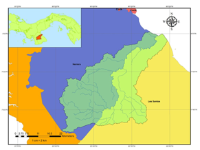
Figure 1.
La Villa’s watershed regional localization ma
The study is based on climate change projections from the Coupled Model Intercomparison Project Phase 5 (CMIP5), published in the Fifth Assessment Report of IPCC (IPCC- AR5). Downscaled projections for the selected models with 1-kilometer spatial resolution were obtained from WorldClim. WorldClim is a dataset of global climate, open access, available for the purposes of modeling climate variables, including, past, present and future projections.
Considering the range of models tested in CMIP5, available WorldClim projection and guidance from the CATHALAC’s research project “Water security and climate change”, the generated models projections chosen for the study were CNRM-CM5, MIROC5, MRI- CGCM3 y NorESM1-M. CNRM-CM5 is a global circulation model developed in France, while MIROC5 and MRI-CGCM3 are both from Japan. Finally, NorESM1-M was developed in Norway.
Those model´s projections were obtained from WorldClim Meteorological Database that allows downloading raster images with a downscaling resolution of 1 km per pixel, in the four RCPs scenarios and historic periods of 2050 and 2070. Another product accessible on WorldClim is a climatological database set which compiles meteorological data from the years 1950 to 2000, necessary to determine climate change anomalies.
With observational data from meteorological stations inside the limits of the watershed, we compared the historical average monthly value against WorldClim’s historic baseline period in aims to observe the capacity of reproduction of the climate variables (precipitation, maximum and minimum temperatures) behavior for the region.
For the selection of the meteorological stations, we considered their location inside the limits of the basin and the historic data available for the climatic variables: precipitation, maximum and minimum temperatures. There es a limited number of meteorological stations within the La Villa watershed. In that regard, Los Santos and Macaracas meteorological stations, which have a record of 42 years of continuum information, were used for this study. Los Santos station is in the lower basin, while Macaracas is on the upper basin.
For maximum temperature, it was required to use data from a near station outside the watershed (Divisa station) because inconsistencies were detected for this parameter in Los Santos station. Finally, in order to extract the values from the raster images (climate change projections and baseline), the ArcGIS software Model Builder application and statistical analysis tools were applied.
A comparison of the WorldClim baseline information against the meteorological station’s data showed that WorldClim represents a good fit to the historical data, since the tendency for monthly average precipitation is similar. However, WorldClim overestimates the
historical values by approximately 26% taking into consideration data for both meteorological stations.
With respect to maximum and minimum temperature baseline data from WorldClim reproduced very well the annual behavior of both variables with an underestimation of approximately 2 °C.
Because precipitation in the tropics is a very difficult to predict variable, the results obtained from the projections are defined by trends. The general trend observed in the analysis for the models shows an increase of the rainfall all year long, for 2050 and 2070. However, each one of the models defines a singular pattern of precipitation during a year as shown in figure 2.
From the four models used, MIROC5 shows the extremist wet scenarios, by exceeding the typically expected rainfall value over a hundred percent for some months. On the other hand, MRI-CGCM3, represents the extreme dry scenarios, being the only one that maintains this behavior for the four scenarios including 2050 and 2070. The magnitude of the negative anomalies reaches a value 44% of decreasing precipitation compared to baseline values.
On the other hand, models CNRM-CM5 and NorESM1-M present intermediate scenarios, alternating between positive and negative anomalies with variations within months that surpass 10% of increase or decrease in rainfall.
The Fifth Assessment Report of the IPCC [5] reports annual average precipitation anomalies varying in ± 10% in the tropics. However, they recognized that this variation can be higher if seasonal periods are considered.
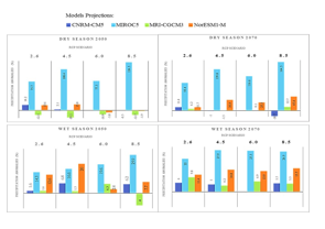
Figure 2.
Annual precipitation anomalies for 2050 in RCP 2.6.
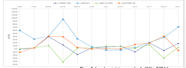
Figure 3.
Seasonal precipitation anomalies resume
La Villa’s rainfall regime has two seasons, first the dry season, which begins in december and last to april, and the wet season that goes to may until november.
In order to see the trend by season, the average anomalies were obtained for the wet and dry season. In this case, precipitation variations present slight differences as compared to the yearly analysis. The results are shown in figure 3.
In both seasons, most of the anomalies tend to be positive, indicating an increase in precipitation throughout the year. Nevertheless, those changes are more accentuated during the wet season than in the dry one.
Those positive anomalies generally vary in a range of 5 to 30 % excluding the over exceeding values presented from MIROC5 model. Meanwhile, negative anomalies reach close to 20% and almost all occurred during the dry season.
In addition, the results indicate a trend of more accentuated positive anomalies for 2070 period than in 2050. This behavior exhibited in models, according to [5], happens due to the increase of temperatures in climate models, results in the increase of precipitation.
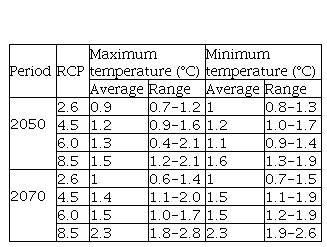
In relation to temperature, all four models show a clear trend of increasing temperature by 2050 and 2070. Because the dispersion within models is not significant, the average anomalies are presented in table 1. One of the most relevant features is that average anomalies increase with the scenarios (from RCP 2.6 to RCP 8.5), for both high and low temperatures. Nevertheless, these values are more severe for the minimum temperature values.
Even if in annual average low-temperature changes rise more than for high temperature, the last one shows us that the probability of occurrence of hot days will increase.
Changes in temperature range between 2 °C to 3 °C, as predicted for the Central American region [5], which also recognizes that by the end of the XXI century changes can reach up to 4 °C.
Temperature anomalies from models’ projections
Using future climate projections downscaled in a proper resolution as a resource; demonstrate that an acceptable level of detail to assess climate change in
smaller areas such as our case of study La Villa River watershed can be obtained.
In this watershed, changes in rainfall estimated by the four models show an annual tendency of increase by the middle and towards the end of the XXI century. Despite the rising amount of rainfall, it does not imply that it would be more water available for consumption. Instead, it is more reasonable to consider an increment in the intensity and frequency of extreme events.
During seasonal periods (dry and wet), average changes in precipitation locate between -20 to +25 % against the typically expected climatology of the period. This supports the probability of an increase of extremes events, drought, and floods, in the dry and wet season respectively.
On the other hand, high and low temperatures according to the four models converge by demonstrating an average increase of 1 to 2 °C, with more severe changes in the southeast part of the basin. In addition, model´s projections identify that by the end of the century temperatures will rise over the 3°C.
As mentioned before, La Villa´s River watershed current climatic vulnerability and challenges for water management make it one of the priority basins in the country. Therefore, it was necessary to estimate climate change’s future influence by using a local scale that could improve the quality of the results.
Besides contributing with scientific climatic information, the most striking aspect in the selection involved was the use of the latest scenarios presented in the IPCC Fifth Assessment Report: Representative Concentration Pathways (RCP). RPC´s are a valuable resource to improve the quality of the predictions of climate models and therefore obtain more accurate climate change projections.
Next steps in this research will be to use the data generated to feed environmental models and obtain the potential effects over hydrological regimen, land use planning, ecosystems functions and economical production.
Advance in Panama´s effort on mitigation and adaptation to climate change will require increasing the country’s capacity on climate modeling, including human resources and infrastructure. As well as policy makers disposition to invest and turn into sustainable initiatives the information generated with this technology.
This research was developed due to the incorporation on the international project Water Security and Climate Change for Latin America and The Caribbean, directed by CATHALAC with funding from the International Development Research Center-IDRC.
Figure 1.
La Villa’s watershed regional localization ma
Figure 2.
Annual precipitation anomalies for 2050 in RCP 2.6.
Figure 3.
Seasonal precipitation anomalies resume
Temperature anomalies from models’ projections