Abstract:
WEPP is a process-based model that estimates runoff and water erosion at slope level, maintaining a soil water balance at daily pace. The objective of this work is to adjust and validate the water balance component of the WEPP model in two watershed management situations (afforestation and natural grassland field) to obtain an adjusted tool that determines runoff and erosion. Soil water content data measured with neutron probe 4 times in the year down to 1.3 m depth during 10 years were used, and were compared with WEPP estimates. The results indicate that the WEPP estimations were not good (Efficiency coefficient (E) = 0.03, -1.29, -0.01, -1.74, 0.17 and -0.08 for the profiles) in high slope (C), average slope (D) and low slope (F), in the Grassland and afforested watershed, respectively, with an E considered insufficient and with periods of over and underestimation water content for both management situations. A better fit was obtained by eliminating the data outside of the calibration line in the profile C, with no improvement for the D and F profiles in both management situations. The results indicate that parameters such as evapotranspiration and WEPP equations must be adjusted to achieve better performance.
Keywords: water balance, WEPP, validation.
Resumen:
El modelo WEPP se basa en procesos que estiman escurrimiento y erosión hídrica a nivel de ladera, manteniendo un balance hídrico del suelo en forma diaria. El objetivo de este trabajo es ajustar y validar el componente balance hídrico del modelo WEPP en dos situaciones de manejo de cuencas (forestada y pastura natural) para obtener una herramienta ajustada que permita estimar escurrimiento y erosión. Se utilizaron datos de agua en el suelo medidos con sonda de neutrones cuatro veces por año hasta 1,3 m de profundidad durante diez años, y se los comparó con los datos simulados con el modelo WEPP. Los resultados indican que la estimación del modelo en los perfiles situados en ladera alta (C), ladera media (D) y ladera baja (F) para ambas cuencas no fue buena (Coeficiente de eficiencia (E) = 0,03, -1,29, -0,01, -1,74, 0,17 y -0,08 para los perfiles C, D y F en la cuenca de pastura natural y forestada, respectivamente), con E considerado como insuficiente y con períodos de sobre y subestimación del contenido de agua en el suelo para ambas situaciones de manejo. Al eliminar los datos de contenido de agua registrados por fuera de la recta de calibración de la sonda de neutrones, los resultados presentaron un mejor ajuste para el perfil C, no registrándose igual mejora para los perfiles D y F en ambas situaciones de manejo. Los resultados indican que se deben ajustar parámetros como la evapotranspiración y las ecuaciones del modelo WEPP para lograr su mejor performance.
Palabras clave: balance hídrico, WEPP, validación.
Resumo:
O modelo WEPP é baseado em processos que estimam o escoamento superficial e a erosão hídrica no nível da encosta, mantendo um balanço hídrico do solo diariamente. O objetivo deste trabalho é ajustar e validar o componente de balanço hídrico do modelo WEPP em duas situações de manejo da bacia (pastagens florestadas e naturais) para obter uma ferramenta ajustada que permita estimar o escoamento superficial e a erosão. Os dados de água no solo medidos pela sonda de nêutrons foram usados quatro vezes por ano, com profundidade de 1,3 m por dez anos e comparados com dados simulados usando o modelo WEPP. Os resultados indicam que a estimativa do modelo nos perfis localizados nos declives alto (C), médio (D) e baixo (F para ambas as bacias) não foi boa (coeficiente de eficiência (E) = 0,03, -1,29, -0,01, -1,74, 0,17 e -0,08 para os perfis C, D e F na bacia de pastagem natural e florestal, respectivamente) com E considerado insuficiente e com períodos de super e subestimação do teor de água no solo para ambos Situações de gerenciamento: Ao eliminar os dados de conteúdo de água registrados fora da linha de calibração da sonda de nêutrons, os resultados mostraram uma melhor adequação ao perfil C, não registrando a mesma melhoria para o D e F em ambas as situações de gerenciamento. Os resultados indicam que parâmetros como evapotranspiração e equações do modelo WEPP devem ser ajustados para alcançar seu melhor desempenho.
Palavras-chave: balanço hídrico, WEPP, validação.
Carátula del artículo
Natural and environmental resources
WEPP model prediction evaluation of soil water content in northeast Uruguay
Evaluación
de predicción del Modelo WEPP del contenido hídrico del suelo en el noreste de
Uruguay
Avaliação preditiva do modelo WEPP de conteúdo de água
no solo no nordeste do Uruguai
 Blanco
,
C. cnicoblanco@gmail.com
Universidad
de la República, Uruguay
Pérez Bidegain,
M. mperezb@fagro.edu.uy
Universidad
de la República, Uruguay
Bentancur,
O. obent@fagro.edu.uy
Universidad
de la República, Uruguay
Agrociencia Uruguay
Universidad de la República, Uruguay
ISSN: 1510-0839
ISSN-e: 2301-1548
Periodicity: Bianual
vol. 24, no. 1, 2020
Received: 02 July 2019
Accepted: 10 March 2020
Published: 21 May 2020
Corresponding author: cnicoblanco@gmail.com
1. Introduction
The Uruguayan territory is comprised entirely within the Río de la Plata grassland region(1), which has been grazed by domestic herbivores for more than 400 years(2). However, in recent years the traditional use of land has changed in some areas of Uruguay due to the development of the forestry sector, which has been increasing the area driven by specific laws (Forestry Law No. 15,239, December 1987)(3). In the 1990-2009 period, the area of forests planted with rapidly developing species, mainly eucalyptus and pine, went from 45,000 hectares to approximately 1,000,000. On the other hand, since forest priority soils cover an area of 3.6 million hectares and the forest industry is in full development with the installation of plants for the production of cellulose pulp and sawmills, it is expected an even greater increase in the area allocated to this item(4). Most of the forested area corresponds to the genuses Eucalyptus (69%) and Pinus (27%). Within the latter, the most widely used species in Uruguay is Pinus taeda, which is currently located in the provinces of Tacuarembó, Rivera and Paysandú(5).
The increase in the area destined to forest plantations supposes a change in the use of the land that, in different spheres (State institutions, private sectors and civil society organizations), raises concerns and questions related to the impact of these plantations on the environment(6)(7), since they generate transformations of large areas that can favor erosive processes linked to the surface circulation of water(8). In the same sense, Ward and Trimble(9) maintain that these anthropic changes produced in the ecosystem can have considerable repercussions on the local water balance. Furthermore, Hewlett and others(10); López and Blanco(11); Daniel and others(12); Spurr and Barnes(13), and Huber and Oyarzún(14) maintain that the presence of the forest changes the redistribution of rainwater, since the amount of water and its distribution in the soil are modified. Given this situation, it is essential to have tools that allow the estimation of soil erosion, taking into account the water balance of the soil in order to predict the amount of water that flows above and below the soil surface, considering the layer-water storage capacity of the same. In this sense, the wepp model is one of the most used tools to simulate erosion and sediment production, and its validation is necessary for the productive conditions in Uruguay.
The objective of this article is to validate the water balance component of the wepp model for afforestation and natural pasture situations in northeast Uruguay.
2. Materials and Methods
2.1 Study site
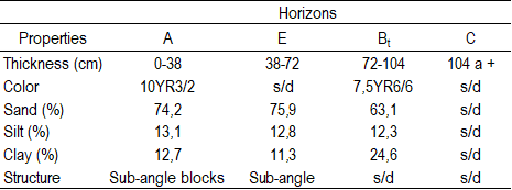
The study was carried out in a basin forested with Pinus taeda and one with natural pasture located in “La Corona” forest establishment, Tacuarembó, Uruguay (31º38’09’’S, 55º41’48’’W). The topography of the basins is characterized by an undulating landscape with rocky hills that stand out from bahop and sandstone. The generating material of the soils are aeolic and silicified sedimentary sandstones from the Tacuarembó Unit(15)(16)(17)(18). According to analytical data, the soil corresponds to a Typic Haplu-dult, as per Soil Taxonomy(19), with variations in the sequence of horizons in its profile. Due to these differences, three monitoring points were taken that correspond to three topographic positions: high slope (profile C), middle slope (profile D), and low slope (profile F).
A Pinus taeda forest was implanted on the Typic Hapludult in one of the basins under study. The technique used for its implementation was to till one third of the area to be afforested using a 4 by 2.5 m planting frame and a density of 1000 trees/ha.
2.2 Measurements
Daily meteorological information (air temperature, relative humidity, rainfall, wind speed and direction, and solar radiation) was obtained through an automatic measurement system (Campbell Scientific cr 10X, Logan, ut, usa) at a weather station nearby to the stand.
The water content in the soil was monitored by neutron thermalization in three topographic positions (high, medium and low) to a depth of 1.3 m, in sections of 0-15, 15-30, 30-50, 50-70.70-90.90-110 and 110-130 cm. In each of the topographic positions, three access pipes were installed in the natural pasture basin and in the row and inter-row of plantation in the forested basin, respectively. The measurements were carried out four times a year during the 2003-2009 period.
Probe calibration was performed by taking soil samples under a wide range of soil water content conditions, and recording the bead ratio readings on the probe.
At the end, undisturbed soil samples were taken from the same depths and the soil water content was determined. Subsequently, the number of counts read on the probe, normalized to a reference value (number of backscattered neutrons within the shield), was related to the moisture content of the soil, for which a regression line was adjusted for different soil layers of the three profiles under consideration (Figures 1, 2 and 3).
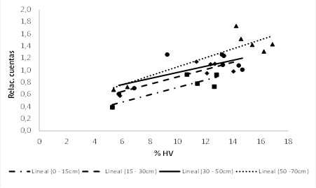 Figure 1
Calibration curves for the first four layers of profile C
Figure 1
Calibration curves for the first four layers of profile C
Where: Relac. cuentas: ratio of counts of the neutron probe. % HV:
percentage of water in volume.
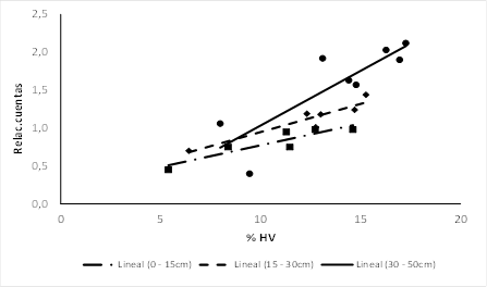 Figure 2
Calibration curves for
the first three layers of profile D
Figure 2
Calibration curves for
the first three layers of profile D
Where: Relac. cuentas:
ratio of counts of the neutron probe. % hv: percentage of water in
volume.
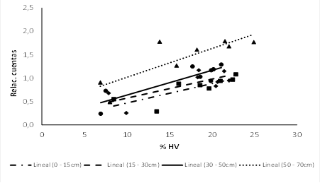 Figure 3
Calibration curves for
the first four layers of profile F
Figure 3
Calibration curves for
the first four layers of profile F
Where: Relac. cuentas:
ratio of counts of the neutron probe. % hv: percentage of water in
volume.
2.3 WEPP entries
The wepp hillside model version
2012.800 was used in this study. This model requires four databases: climate,
topography, soil and crop management(20).
2.4 Climate database
For the elaboration of the climate file in WEPP, the
climate generator BPCDG (Breakpoint data) was employed using the climatic data
of radiation, temperature, dew point, wind speed and direction, relative
humidity and precipitation in the Tacuarembó province from 2003 to 2009.
2.5 Topography database
For the generation of the topography database, the
slope was divided into equal parts, to which a percentage of slope was assigned
that varies within a range for each profile according to what was observed in
pasture. The assigned slope ranges were 12-15% for profile C, 6-12% for profile
D and <5% for profile F.
2.6 Soil database
The characteristics of the profiles that occupy
different topographic positions on the slope are presented in Tables 1, 2 and 3.
Table 1
Description of the soil
of profile C (high slope)
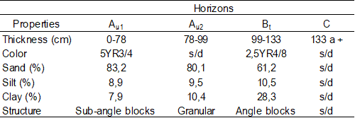
Table 2
Description of the soil
of profile D (middle slope)
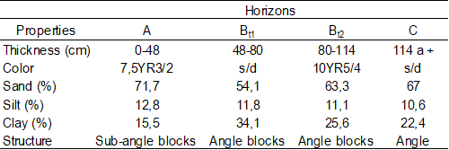
Table 3
Description of the soil
of profile F (low slope)
In the soil database, a division was made between the
soil profiles where Pinus taeda was implanted and
those found in the interfile with natural pasture. The fact of having worked
only the portion of soil where Pinus taeda was to be
implanted caused the loss of part of horizon A. To simulate this loss of soil,
the upper 20 cm of horizon A were removed from the three profiles corresponding
to the row of Pinus taeda. This division in the
database leads to two surface flow elements. For the natural pasture basin no changes were made to the soil profile data.
2.6
Management database
The default values for wepp were used in the “Forest
Perennial” and “Short grass praire” databases, with
the exception of radiation use efficiency (ber), cardinal temperatures for
Pinus taeda, rooting depth, and foliar area index (iaf). In the
case of the rooting depth for natural pasture, no modifications were made, but
for Pinus taeda, variations were used according to
the profile under consideration, reaching the upper part of the argilluvic horizon. Table 5 presents the values of the parameters that were modified in the
management database mentioned above.
The data of these parameters were taken from investigations carried out for regional conditions, which allow the model to perform a simulation of Pinus taeda growth similar to that observed.
For the natural pasture situation, since it is a community of species that coexist in space and time, it is difficult to have a single value of some parameters, such as cardinal temperatures. Given the dominant soil type in this basin, there is a wide predominance of summer species, and for this reason, Paspalum dillatatum was considered the dominant species. Bibliography data were used to simulate the biomass production of the natural pasture (Table 4).
Table 4
Parameters used in wepp
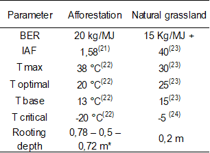 * Rooting depths for profiles C, D and F, respectively. + Adjusted trying to achieve adequate biomass production...
2.7 Validation of the Water Balance
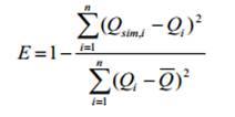
The efficiency coefficient(25)
was used, by means of which the observed data are compared with those simulated
by the model according to the following equation:
Where E is the efficiency of the model, Qi represents the observed value of event i, Qsim, is the simulated value of event i, and Q (Q bar) is the mean of the observed values.
To validate the model, the linear regression was estimated, considering the intercept and the slope of the regression line, taking a significance level of 0.05.
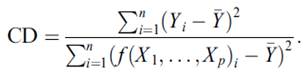
In addition, the coefficient of determination (cd) proposed by Tedeschi(26) was taken into account, according to the following equation:
where CD is the coefficient of determination, Yi is
the ith observed value, Y (Y bar) is the average of
the observed data and ƒ(X1, ..., Xp)
are the values estimated by the model.
2.8
Transparency
of data
Available data: The entire
data set that supports the results of this study was published in the article
itself.
3. Results
Figures 4, 5 and 6 show the evolution of the water content measured and simulated by wepp in the root zone for the soil profiles considered in the three different topographic positions (profile C: tall ladder, profile D: middle slope and profile F: low slope) on the same slope from 2003 to 2009 for the natural and forested pasture slope, respectively.
In soil water balance, evapotranspiration and soil water storage capacity are, in general, two very important factors. These components determine that plants have more or less water for their growth. In the study area, validation was carried out for the natural pasture basin, and the row of pines in the forested basin up to where the argilluvic horizon began for each of the profiles (Figures 4, 5 and 6).
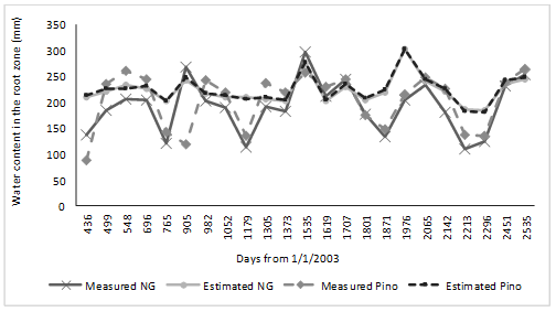 Figure 4
Comparison of water
content data in the root zone measured and simulated by wepp for three repetitions of
profile C on average. (Natural Grassland (ng))
Figure 4
Comparison of water
content data in the root zone measured and simulated by wepp for three repetitions of
profile C on average. (Natural Grassland (ng))
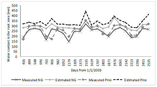 Figure 5
Comparison of water
content data in the root zone measured and simulated by wepp for three repetitions of
profile D on average. (Natural Grassland (ng)).
Figure 5
Comparison of water
content data in the root zone measured and simulated by wepp for three repetitions of
profile D on average. (Natural Grassland (ng)).
 Figure 6
Comparison of water
content data in the root zone measured and simulated by wepp for three repetitions of
the profile F on average. (Natural Grassland (ng)).
Figure 6
Comparison of water
content data in the root zone measured and simulated by wepp for three repetitions of
the profile F on average. (Natural Grassland (ng)).
Although the parameters suggested by the bibliography
were used, which allowed the biomass production to be correctly simulated, in
profiles C and F there were situations of over and underestimation of water in
the soil by the model. Profile D generated a situation of overestimation of
soil water by the model throughout the evaluation period. Although in general
the model simulated the trend of the evolution of soil water, at some specific
points in the evaluation there was a greater mismatch between the water content
simulated by the model and that measured in natural grassland. For example, on
day 905 of the evaluation period, the model had an increase in the water
content of the soil, while in the soil a decrease was registered, therefore
resulting in opposite behavior for the three
profiles. According to the results of the statistical analysis shown in Tables 5 and 6, in none of the three profiles a Nash Sutcliffe
Efficiency coefficient was considered acceptable(25).
These insufficient efficiency values coincide with those reported by Savabi and others(27),
who working on plots in natural pasture obtained an efficiency coefficient of
0.46.
Table 5
Forested basin
statistical indicators.
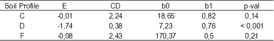 E; CD; b0, b1 are the coefficient of efficiency, coefficient of determination, intercept, and slope of the regression line, respectively.
Table 6
Statistical indicators
of natural grassland basin
 E; CD; b0, b1 are the
coefficient of efficiency, coefficient of determination, intercept, and slope
of the regression line, respectively.
E; CD; b0, b1 are the
coefficient of efficiency, coefficient of determination, intercept, and slope
of the regression line, respectively.
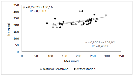 Figure 7
wepp simulation regression line
for C profile and perfect fit line. Natural pasture.
Figure 7
wepp simulation regression line
for C profile and perfect fit line. Natural pasture.
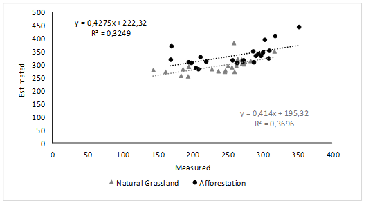 Figure 8
wepp simulation regression line
for D profile and perfect fit line. Natural pasture.
Figure 8
wepp simulation regression line
for D profile and perfect fit line. Natural pasture.
 Figure 9
wepp simulation regression line
for F profile and perfect fit line. Natural pasture.
Figure 9
wepp simulation regression line
for F profile and perfect fit line. Natural pasture.
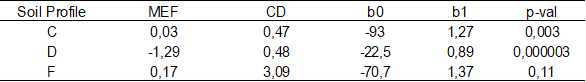
Of the three profiles analyzed, profiles C and F presented the highest cd values (Table 1), with the variance of the data observed with respect to the simulated ones being greater in both cases, although with similar average values. In these two situations, to reduce the variance of the simulated data, the model had to overestimate the low values of water content and underestimate the high contents. This can be seen in Figures 4, 5 and 6.
Due to the model lack of adjustment, it was decided to analyze three points considered key to the water balance. In the first instance, it was decided to make a comparison of the estimation of the evapotranspiration simulated by the wepp model for natural pasture, since, being a pasture, it can be considered as having a cultivation coefficient close to one, so etc (Evapotranspiration of the cultivation) is very similar to et0 (Potential Evapotranspiration), which allows the comparison with the information provided by inia Tacuarembó, where the Penman Monteith equation is used. Once the averages for the different years of the evaluation period were carried out, it was observed that the wepp model estimated an evapotranspiration lower than that estimated by inia, so the soil would be more humid according to the model than what actually occurs (table 7).
Table 7:
Comparison of average
Evapotranspiration (et) values
estimated by wepp
and that reported by inia.
Secondly, given that during the
probe calibration procedure it was difficult to extract samples from soils with
the lowest water content, it was decided to eliminate those soil water
measurement points from profiles C and D that remained outside the regression
line (Fig.
7
and 8). In the case of profile F, there were no points outside the regression
line used in the calibration (Fig. 9). For profile C, with
the elimination of these data, a closer approximation of the observed and
simulated data was achieved, allowing the correction of the lags that were
generated when all the data were used, as shown in Figure 10. And even the
efficiency coefficient considered as insufficient according to Molnar cited by
Cabrera(28) (mef = -0.01) started to have
higher values (mef
= 0.60 and 0.74 for afforestation and natural pasture, respectively), with a
regression line that does not deviate significantly from the perfect fit line
(p val> 0.05). On the other hand, for profile D
there were no significant changes in the efficiency coefficient, maintaining
negative values. The regression line of said profile did not show significant
changes either.
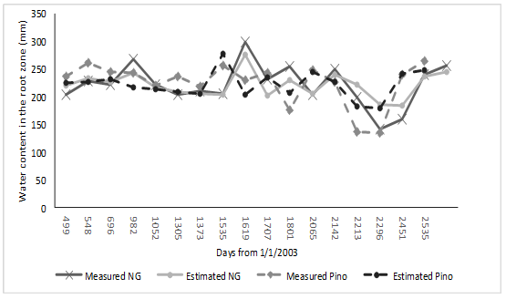 Figure 10
Comparison of water
content data in the root zone measured and simulated by wepp for three repetitions on
average of profile C with less data.
Figure 10
Comparison of water
content data in the root zone measured and simulated by wepp for three repetitions on
average of profile C with less data.
As a third point, the
sub-superficial lateral flow was considered. However, even with these
adjustments, efficiency coefficient values that are not acceptable continue to
be obtained. This may be because the model has not generated lateral subsurface
flow as observed in the field. This can alter the simulation of the
redistribution of the water once it enters the ground, and therefore generate
that gap between the observed and simulated data.
4. Conclusions
The results indicate that the wepp model was not able to simulate the water content of the soil in an acceptable way, since adequate values of the Nash Sutcliffe efficiency coefficient have not been obtained for the three profiles considered in both management situations. The model has generated in most cases an overestimation of the water content of the soil, due in part to the lower simulated evapotranspiration compared to what actually occurs.
On the other hand, drawbacks have been detected in the calibration of the neutron probe with low soil water contents and less evapotranspiration by the model. As a consequence, to achieve a better fit, some correction should be made to the established values, such as the leaf area index, in order to improve the simulation of evapotranspiration and thus achieve an adequate simulation of the soil water content using the model wepp.
Additional information
Author contribution
statement: CB: Wrote the manuscript and
participated in the analysis and interpretation of results. MPB: Participated
in writing the manuscript and the analysis and interpretation of results. OB:
Made contributions to the statistical analysis of the data.
Editor: The following editor approved this
article.
Mónica Barbazán.
ORCID: https://orcid.org/0000-0002-0028-4870 Universidad
de la República, Montevideo, Uruguay.
References
1. León R. Río de la Plata grasslands: Regional sub-divisions. In: Coupland RT, editor. Ecosystems of the World 8A Natural grasslands. Amsterdam: Elsevier; 1992. p. 376-407.
2. Piñeiro G. Impactos de la ganadería sobre la dinámica de C y N en los pastizales del Río de la Plata. In: Bases ecológicas y tecnológicas para el manejo de pastizales. Montevideo: INIA; 2011. p. 79-96. (Serie FPTA; 175).
3. Barreto P. Efectos iniciales de la aforestación sobre la calidad del agua de escurrimiento en una cuenca del Río Tacuarembó (master’s thesis). Montevideo (UY): Universidad de la República, Facultad de Agronomía; 2008. 64p.
4. Silveira L, Chreties C, Alonso J, Amorín C, De Izaguirre P, Crisci M, Symonds S, Martínez L, García M, García F, Delgado S, Clérici C, Bentancor L, Hill M, Alliaume F, Cabral P, Audicio P, Iroumé A, Huber A, Schipilov A. Efectos de la actividad forestal sobre los recursos suelos y aguas. Montevideo: INIA ; 2011. 34p. (Serie FPTA; 32).
5. Ministerio de Ganadería, Agricultura y Pesca, Dirección General Forestal (UY). Estadísticas forestales 2019 (Internet). Montevideo; MGAP; 2019 (cited 2020 May 08). 65p. Available from: https://bit.ly/2L8od5e.
6. Silveira L, Martinez L, Alonso J. Efecto de la sustitución de campo natural por plantaciones forestales, sobre los recursos hídricos en el Uruguay. Agrociencia. 2006;10(2):75-93.
7. Chescheir GM, Von Stackelberg N, Amatya D, Skaggs R. Effects of afforestation on the hydrologic behavior of a basin in the Tacuarembo River. Raleigh: North Carolina State University; 2004. 56p.
8. Edeso J, Marauri P, Merino A, González MJ. Determinación de la tasa de erosión hídrica en función del manejo forestal: la cuenca del río Santa Lucía (Gipuzkoa). Lurralde. 1997;(20):67-94.
9. Ward A, Trimble S. Infiltration and Soil Water Processes. In: Environmental hydrology. London: Lewis Publishers; 2004. p. 55-80.
10. Hewlett J, Nutter W. An outline of forest hydrology. Georgia: University of Georgia Press; 1969. 137p.
11. López C, Blanco C. Hidrología Forestal: Primera Parte. Madrid: Escuela Técnica Superior de Ingenieros de Montes; 1976. 387p.
12. Daniel TW, Helms JA, Baker FS. Principios de Silvicultura. 1st ed. México: McGraw-Hill; 1982. 492p.
13. Spurr S, Barnes B. Ecología Forestal. México: AGT Editor; 1982. 690p.
14. Huber A, Oyarzún C. Variaciones anuales en la precipitación, escurrimiento e intercepción en un bosque de Pinus radiata. Turrialba. 1990;40(4):503-8.
15. Sacco G, Falco L. Estudio semi-detallado de suelos. Montevideo: CIAAB; 1975. 24p.
16. Durán A. Orden III: Suelos saturados lixiviados. In: Los Suelos del Uruguay. Montevideo: Hemisferio Sur; 1995. p. 187-256.
17. Falco L. Estudio de suelos en el Departamento de Tacuarembó a escala 1:100000: Formación Tacuarembó: Mesozoico Triásico. Montevideo: MGAP; 1996. 51p.
18. Pérez Gomar E. Sistema solo-planta de campo nativo submetido ao uso de herbicidas para semeadura direta de forrageiras de estacao fría (master’s thesis). Santa María (BR): UFSM; 1999. 81p.
19. USDA. Claves para la Taxonomía de Suelos. 12nd ed. Washington: USDA; 2014. 399p.
20. Nicks AD, Lane LJ, Gander GA. Weather generator. In: Flanagan DC, Nearing MA, editor. USDA-Water Erosion Prediction Project: Hillslope Profile and Watershed Model Documentation. Lafayette: USDA; 1995. p. 2.1-7. Report No.: 10.
21. Gándara J. Curso estacional del estado hídrico, crecimiento y actividad fotosintética en un rodal de Pinus taeda L. en Uruguay (master’s thesis). Montevideo (UY): Universidad de la República, Facultad de Agronomía; 2013. 104p.
22. Landis TD. Manual de viveros para la producción de especies forestales en contenedor. Manual agrícola. México: Universidad Autónoma Chapingo; 2000. 126p. N° Folleto: 16175.
23. Carámbula M. Características y comportamiento productivo de las especies templadas, sub-tropicales y tropicales. In: Pasturas naturales mejoradas. Montevideo: Hemisferio Sur; 1997. p. 29-41.
24. Lezama F, Altesor A, Pereira M, Paruelo JM. Descripción de la heterogeneidad florística de las principales regiones geomorfológicas de Uruguay. In: Bases ecológicas y tecnológicas para el manejo de pastizales. Montevideo: INIA; 2011. p. 15-32. (Serie FPTA; 175).
25. Nash JE, Sutcliffe JV. River flow forecasting through conceptual models: Part I A discussion of principles. J Hydrol. 1970;(10):282-90.
26. Tedeschi LO. Assessment of the adequacy of mathematical models. Agric Syst. 2006;(89):225-47.
27. Savabi MR, Young RA, Benoit GR, Witte JM, Flanagan DC. Winter Hydrology. In: Flanagan DC, Nearing MA, editor. USDA-Water Erosion Prediction Project: Hillslope Profile and Watershed Model Documentation. Lafayette: USDA ; 1995. p. 3.1-18.
28. Cabrera J. Calibración de modelos hidrológicos (Internet). (place unknown): (publisher unknown); (date unknown; cited 2020 May 08). 7p. Available from: https://bit.ly/2SMAUHa.
Notes
Author notes
cnicoblanco@gmail.com